


A-SKY AK718 GNSS RTK Survey Station
3167.99 €
🆓 FREE SHIPPING with tracking number!
✅ No Import Taxes on delivery!
🏷️ Condition: New
🚚 Ships from: HK Warehouse – Hong Kong (China)
↩️ Easy Returns within 30 days of receipt
🙋 Any questions? Contact Jake
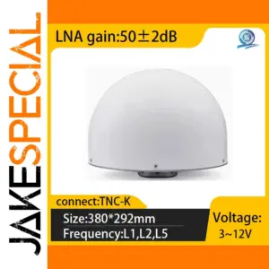
Experience high-precision positioning with the A-SKY AK718 GNSS RTK differential CORS station, featuring a sleek, white, dome-shaped antenna optimized for outdoor use. With a size of 380 x 292 mm and equipped with a TNC-K connector, it operates across L1, L2, and L5 frequencies, supported by a high-gain LNA of 50±2dB within a voltage range of 3-12V. Its durable, minimalist design combines industrial robustness with modern aesthetics—ideal for professional geospatial, surveying, and mapping applications, ensuring accurate and reliable signal reception in demanding outdoor environments.
This high-precision A-SKY GNSS AK718 station for accurate surveying
Imagine enhancing your surveying projects with this advanced GNSS RTK differential CORS station, model AK718 by A-SKY. Its sleek, dome-shaped antenna with a smooth matte white finish offers a modern, professional look while providing durability for outdoor use. Designed with four-star full-frequency capabilities, this station covers L1, L2, and L5 bands, ensuring reliable, precise positioning even in challenging environments. The compact size of 380 x 292 mm makes it portable yet robust enough for fixed installations. With a TNC-K connector and an impressive LNA gain of approximately 50±2dB, the AK718 guarantees high signal reception quality. Its versatile voltage range of 3-12V enhances compatibility with various power sources, making it ideal for geospatial, construction, or mapping projects requiring high accuracy. This system embodies technological excellence for professional surveyors.
Keys features of the product AK718 by A-SKY
- High-precision GNSS RTK station supporting L1, L2, and L5 frequencies, suitable for versatile advanced positioning applications.
- Sleek dome-shaped antenna with a smooth matte white finish, combining high tech aesthetic with outdoor durability and easy installation.
- Equipped with a TNC-K connector and an LNA gain of 50±2dB, guaranteeing excellent signal reception and low noise for precise data collection.
- Compact dimensions of 380 x 292 mm, designed for portability and easy integration into various survey setups in professional environments.
- Operates within a voltage range of 3 to 12 volts, ensuring flexible power supply options suitable for different field conditions.
- Manufactured by A-SKY, model AK718—an ideal reference station for geospatial, construction, and mapping tasks demanding high accuracy.
This A-SKY GNSS AK718 station is a must-have—order now for precise results!
Experience the reliability and advanced technology of this high-precision GNSS AK718 station. By choosing this robust, full-frequency reference system, you'll ensure your surveying projects are accurate and efficient. Whether working on construction sites, topographic surveys, or mapping projects, this station offers consistent, real-time positional data. Its modern design and technical capabilities make it an invaluable tool for professionals seeking top-tier performance. Don’t miss the opportunity to elevate your surveying accuracy—invest today and take your work to the next level with confidence and precision!
| Color | AK718 |
|---|---|
| Condition | New |
| Warehouse | HK Warehouse – Hong Kong |
🌟 Every Purchase Comes with Direct Access to Jake 😎 from JakeSpecial, PhD in Pure Mathematics, Innovator and Entrepreneur — bringing broad expertise and trusted insight across all Special items & ensuring expert support and guidance at every step.
WHY CHOOSE JAKESPECIAL? 🤔
Shopping online isn't just about buying a product—it's about having a smooth, reliable, and worry-free experience. At JakeSpecial, I don't just sell products, I ensure that every order is handled with care, efficiency, and full support 🌟

Here's why you can shop with confidence:
1. Customer Service That Has Your Back 🤝 – If there's any issue with your order, I personally handle it—no delays, no excuses. Whether it's a delivery concern, a damaged item, or any other issue, I fix it, fast.
2. Hassle-Free Resolutions ✨ – Unlike many sellers who dodge responsibility, I take full ownership of every sale. If there's a problem, I solve it directly. Your satisfaction is my priority.
3. Fast & Reliable Shipping 🚀 – My shipments are integrated into high-priority international logistics networks through Cainiao Global Express, ensuring most orders arrive within 7-10 days.
4. Full Tracking Transparency 📍 – Every order comes with a tracking number that lets you monitor your package in real time.
5. Expertise in Business & Problem-Solving 🎓 – I am not just an entrepreneur in the e-commerce business; I also hold a PhD in Mathematics and continue to work at the frontier between computer science and pure mathematics. My expertise spans multiple advanced fields, allowing me to approach complex logistical, operational, and technical challenges with precision and efficiency. This mindset of structured problem-solving and analytical thinking is what enables me to offer a smooth, optimized, and highly reliable shopping experience. Whether it's managing logistics, handling unexpected issues, or improving customer service, I apply the same rigorous problem-solving approach that I use in advanced mathematical research.

When you buy from JakeSpecial, you're not just getting a product—you're getting a professional, well-managed, and worry-free shopping experience with full customer support and a problem-solving approach you won't find elsewhere 💫
FAST & SECURE SHIPPING 📦
I use fast, reliable, and monitored logistical routes to your region. Once your package reaches your country, it is handed over to a local subsidiary of Cainiao Global Express or a major national carrier, such as Evri or Royal Mail for the UK, Colissimo for France, Poste Italiane for Italy, Correos for Spain, or Bpost for Belgium 🌍
I typically dispatch items within 2 business days for products shipped from my warehouse in France and within 5 business days for products shipped from my Hong Kong warehouse. Every package comes with a tracking number, with estimated delivery times ranging from 10 to 20 days, depending on your location. However, most packages arrive within 7 to 10 days ⚡
Q: How long does shipping take? ⏱️
A: Most packages arrive within 7-10 days, with full tracking available. The Cainiao Global Express logistics network ensures reliable transit times, unlike standard shipping services that may take much longer.
Q: What is the journey of a package? 🗺️
A: Every package follows a highly optimized and secure logistics path to ensure fast and reliable delivery. It begins at my warehouse in Hong Kong, where it is prepared for shipment before being transferred to Cainiao Global Express' logistics hub in Mainland China, marking the official start of the shipping process. From there, the package moves through Cainiao's high-efficiency logistics network, ensuring continuous monitoring and rapid transit to its destination country. Once it arrives, it is either handed over to a local Cainiao subsidiary or entrusted to a major national carrier for smooth final delivery. This process guarantees secure, fast, and well-tracked shipping, providing the same level of efficiency as major global retailers.
EASY RETURNS 🔄
If you need to make a return, there's no need to ship the item all the way back to Asia. I make returns easy by accepting them directly at my warehouse in Marseille, France. Feel free to reach out to me — I'm here to make the process as smooth as possible 📬
TRANSPARENCY AND EXCELLENCE ✨
All items are presented accurately in photos and descriptions. If you have any issues with your purchase, please contact me. Your satisfaction is my top priority 💯
PASSION & UNIQUE EXPERTISE 💪
I take pride in offering meticulously crafted items, carefully curated by me, Jake, PhD. Together with Marwa, we bring passion and excellence to every detail ❤️

Related products